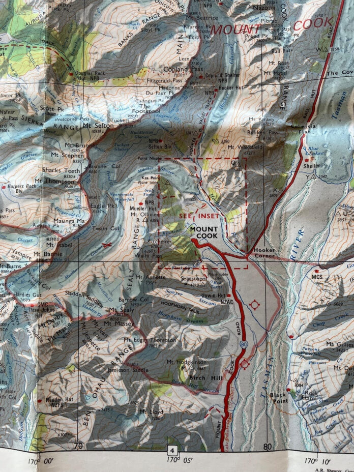
Aoraki Mt Cook National Park in 1973
I’ve just come back from spending a week as a voluntary DOC warden at Mueller Hut in Aoraki Mt Cook National Park. Before leaving I rummaged through old maps and found a 1973 map of the area to save buying a new map.
So what has changed in the last 50 years?
In 1973 there was no Mueller Lake, Hooker Lake or Tasman Lake which are key features of the area today. Back then the Mueller, Hooker and Tasman glaciers extended through these valleys and the areas these lakes now occupy. In each case the glaciers have receded dramatically leaving just these large grubby puddles. The view from near Mueller Hut shows the Mueller glacier now backed up to the very end of the valley with kilometres of empty, gravel-covered valley left behind. From the ridge above the Mt Cook village one can’t even see the Hooker Glacier which is now hidden well up the Hooker Valley.
In 1973 ski planes would land on the Mueller Glacier and people would ski down the valley on the snow-covered glacial ice. Not any more.
These are massive, dramatic changes in the landscape in just 50 years. They can either be a reason for sadness or a reason to galvanise all of us concerned for the future of humanity and the planet we depend on for survival.
Where do you stand?


Change will not happen with more conferences or doom laden documentaries about tipping points. All but the most committed deniers or right wingers know after Cyclone Gabrielle that something serious is well upon us. When housing is uninsurable and there are designated no build zones the message will have sunk in.
Direct Action is what is needed, including Climate Strikes that build to the point of tactically paralysing industry and agriculture until Industrial Dairying pulls it head in. It is great to see a national School Climate Strike group rebuilding and getting active again. It is new gens that will lead this movement.
The 50 year period John describes is enough time to monitor change, and this can be done in many parts of country when you check coastline retreat, erosion and poisoned waterways. Take the people who get around this countrys word for it–we are in a climate disaster.
–Sustainable energy including booting Rio Tinto and returning power generation and supply to full public ownership, solar installs & rain water collection on houses
–mass restoration of public transport, rail networks and NZ owned coastal shipping that works, big subsidies on EVs
–Green public works and infrastructure Dept.
for starters…
Tasmania has adopted a plan called ‘200% by 2040’, overseen by their Department of State Growth, which is intended to double the state’s electricity generating capacity by 2040, but all on the basis of renewables, to build up a surplus for hydro dry years I believe and also to attract Green industries. Of course, in this country, any such proposal would probably attract accusations of Muldoonism (especially if overseen by an outfit called the Department of State Growth) and, what’s more, of imperiling the profits of the present electricity suppliers.
Worth voting for Tiger. It’s what a transformative Labour government should have been planning and undertaking rather than trying to alleviate the symptoms of Neoliberalism.
You can check out the original map in digitised form on Mapspast: http://www.mapspast.org.nz/mapsheet/34.
A very useful site for seeing how Ao/NZ has changed, including the growth of Auckland.
At least the huts there are not smouldering ruins.
Check this out, from 31 March, as well: https://www.theguardian.com/world/2023/apr/01/slipping-through-our-fingers-new-zealand-scientists-distraught-at-scale-of-glacier-loss
And the 1946 map here: https://www.a-maverick.com/blog/aoraki-mount-cook
Thanks so much for your informative posts Chris.
I ordered some historic photos of Karikari Peninsula in Far North where I live a while back for our Beach Care Group. The pics were taken in a 1940s aerial survey and it showed that the main beach–Tokerau, 20km long–used to have three rows of sand dune systems between water and main land area, in 2023 it barely has one. People are still full steam ahead building in 1980s era approved developers subdivisions though!
You are welcome. Yes, I believe that Tokerau Beach has a history of being washed away, viz: https://www.nzherald.co.nz/northland-age/news/far-north-communities-must-act-now-to-adapt-to-climate-change-say-experts/QC3FBR3K5CBNQFJYX64PDABEKY/. More generally, a lot of our coast is very dynamic and more so than we like to think, e.g. Victorian maps of the Brighton Spit in Christchurch show it in different places from now, esp. at the tip.
Comments are closed.